Friday, November 19, 2010

Cool Hubble Pics


The beauty of some of these nebulae is astonishing. One could look at a nebula and be looking 400 million years ago. That's how long it takes (linear) light year time for it to get to planet Earth. This may change as we learn that not all movement is linear...maybe there's multi dimensional travel.

Wednesday, November 3, 2010

Brand Peak NE Trail (3)


Great sunset and ocean pics...one could see the US Naval island SW of Catalina as well.

Brand Peak NE Trail (2)


Now pics from the summit area...

Brand Peak hike NE from Brand Library 11-02-2010


This day was one of the few spectacular (clear) days in the basin. Here are pics from the summit towards the ocean. This was getting from 330P to 630P...this is a nice quick hike...the basic hike is .8 mile long and 1600 elevation gain/loss. The toyon berry now coming out quick with holiday red berries. Black flies still out at this late date. Noted an owl after sunset. Los Angeles is amazing to look at from above. Many loops can be done in the Verdugos. Several other trails occur near the library that are just as steep and a few miles more. The vegetation coming back a lot since the 2002 fire.

Crystal Lake in 2010


Here are examples of over use in the Angeles National Forest. In 1998, it's estimated that 40 million people went into and out of these mountains. This lake was a nice clear blue in 1987. Here is what it looks like with irresponsible and collective use of this national forest. These are also the results of new Orwellian policies thrusted against the hordes of vigilantes. One could also say they are the results of unmolested global capitalism courtesy of the 1994 GATT/NAFTA agreements. We are all responsible collectively...so the collective thinking of one's individual actions probably to the key to see how all this could propagate. Maybe today ( or recently) a good 70 million attend the forest; in fact the Angeles Forest Highway has been used as a commute road since the new economics from the late 1980s. It's a wonder that it hasn't been worse...hopefully people will wake up from their dream like states and respect the very Nature that a Higher Power made them from.

Mt Islip (3) 9-11-2010


More pics...now it's gradually getting up to the peak and savoring the almost 360 view. Los Angeles had a murky layer of smog/haze that day.

Mt Islip (2) 9-11-2010


More pics of the trip...mostly in sequential order.

Mt Islip 9-11-2010


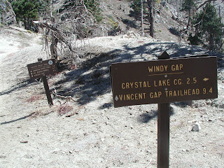
Got to Mt. Islip in early September. A whole bus load of Japanese hikers around 70 years old also climbed the peak that day. Happily the Angeles Forest is still green and well from Chilao Flats to the N by NE. However, the Big Tujunga wash area very devastated. There are signs of plant life rebounding very quickly (as after the great fire of 1975). One hikes about 2 miles in and elevates 500 feet to get to Little Jimmy Camp. The facilities in bad repair but still usable as of 2010. This is a truly wondrous campsite laden with Ponderosa, sugar, Jeffrey and limber pine. There's also fir and incense cedar in places. This is a campsite about .25 X .10 mile and just a charming spot. From there, one can get to the peak in about the last mile and another 1200 feet elevation gain. One first goes past Windy Gap (so named because it's almost always windy there)...the saddle between Mt. Hawkins and Mt. Islip. One can go left to Hawkins or right to Islip. The conifers devasated, here, by 2004 fire and a pine blister beetle since the mid 1990s...this seemingly goes to at least Mt. Baldy and maybe into the front flank of the San Bernardino mountains. Great views from Islip and there was once a lookout cabin up there. One can see most all the San Gabriel range, Sierra Nevadas to the north, Los Angeles Basin, and Ventura Mountains to the west (on a very clear day).

San Rafael Hills 9-6-2010


Here's some of the nicer spots along the Cerro Negro trail. One can access the hills from several points and make small loop hikes. Great views of Pasadena area, Glendale, ocean, and Crescenta Valley.

Beaudry Trail from Oakmont Golf Course (Canada Country Club)


A view of Beaudry in early September. The buckwheat and chamise alive with red -brown colors. Small hints of fall just coming in...the sycamores may yellow along with the poison oak. This trail loops; one can go up the Beaudry north and down the Beaudry south. It makes for a nice comparison of the south versus north slope vegetation. A lot of garden spiders this year.